As any of you may have noticed (if you were following my blog many moons ago). I have not posted for some time. Yes, it seems I dropped off the radar. I really have no excuses I suppose. I guess life just swept me off my feet. So, I wanted to throw this random post into this section of the blogging trail. I don't have the best memory, but thankfully I seemed to keep my Facebook picture albums and page better updated, so I am going to try to use that as my guide and update my blog as well. I can't guarantee that after I accomplish this goal, I won't have to turn around in another year and do the same thing. But, let's stay optimistic, shall we?
Sunday, December 30, 2007

Wednesday, December 5, 2007
Tó Naneesdizí (Tuba City)
I spent September - December working in Tuba City on a Navajo/Hopi Indian Reservation. The pleasure was all mine! What I learned from these proud people I will carry with me forever.
The name of the town honors Tuuvi, a Hopi headman from Oraibi. The Navajo name for Tuba City, Tó Naneesdizí translates as “tangled waters” which probably refers to the many springs below the surface of the ground which are the source of several reservoirs.
I lived in Flagstaff, AZ which is the first town you come to leaving the reservation, heading south/west. The reservation does not recognize the time change. Therefore, I had (at the beginning of my stay) a 3 hr difference that I had to accommodate. I also had a 77 mile trip one way. I put ALOT of miles on my car, but seeing the change in scenery was amazing, and we all know how much I love to drive! Here's a bit of a photo documentation of my daily commute.






The name of the town honors Tuuvi, a Hopi headman from Oraibi. The Navajo name for Tuba City, Tó Naneesdizí translates as “tangled waters” which probably refers to the many springs below the surface of the ground which are the source of several reservoirs.
I lived in Flagstaff, AZ which is the first town you come to leaving the reservation, heading south/west. The reservation does not recognize the time change. Therefore, I had (at the beginning of my stay) a 3 hr difference that I had to accommodate. I also had a 77 mile trip one way. I put ALOT of miles on my car, but seeing the change in scenery was amazing, and we all know how much I love to drive! Here's a bit of a photo documentation of my daily commute.

I passed by this tree twice a day and something about it made it stick out to me.

View of all the trees lining the mountains.
Another great view I obtained daily was of the San Francisco Peaks. The San Francisco Peaks are one of four sacred mountains known to certain Native American tribes. These peaks form the Navajo sacred mountain of the west, called the Dook'o'oosłííd in their language. Navajo people believe that the Holy People instructed them never to leave the land between four sacred mountains located in Colorado, New Mexico, and Arizona. To the south is Mount Taylor; to the east is Blanca Peak, and to the north is Hesperus Peak. There is a sacred object and a color representing each of the four cardinal directions. To the east is the white morning sky; its precious stone is white shell. To the south is blue and turquoise. To the west is yellow, and the corresponding stone is yellow abalone. To the north is black and jet.

San Francisco Peaks...one of the four sacred mountain groups.
Approaching a pull off for 'Genuine Indian Jewelry', a sign reads: 'Friendly Indians Here, Chief Yellow Horse Loves You'. Then, after passing the pull off, big signs state: 'Friendly Indians Behind You, Turn Back Now'.

Chief Yellowhorse LOVES you!!
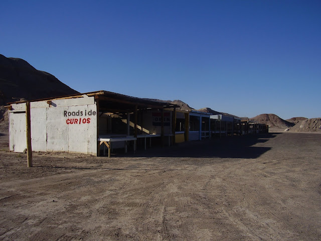
A little play on words describes my next photo. A curio (referring to a curio cabinet) is a predominantly glass cabinet with a metal or wood framework used to display collections of figurines that share some common theme. Roadside vendors here used 'curios' to display their works (dolls, art, jewelry, etc.).

Vacant roadside Curio(s)
Random shots of landscape on the reservation.


Old Home near hospital.
Another item I passed daily was a sign honoring local Navajo Code Talkers. Code talkers is a term used to describe people who talk using a coded language. They transmitted their messages via military telephone or radio using codes developed built upon their native language, which was virtually impossible to translate by the enemy. Their services were used during both World War I (Choctaw), and World War II (Navajo) and was a valuable resource contributing to communication security of vital front line operations.
The code talkers received no recognition until the declassification of operations in 1968. It wasn't until 1982 that they were given a Certificate of Recognition by President Reagan, naming
August 14th 'Navajo Code Talkers Day'. Years later numerous surviving code talkers, and families of non-surviving members, received Congressional Gold Medals.
On December 13, 2007 (during my travels in this area), the Code Talker Recognition Act, was introduced to the House of Representatives. The Code Talker Recognition Act recognizes every code talker who served in the United States military with a Congressional Gold Medal for his tribe, and a silver medal duplicate to each code talker, including eight Meskwakis.
On December 13, 2007 (during my travels in this area), the Code Talker Recognition Act, was introduced to the House of Representatives. The Code Talker Recognition Act recognizes every code talker who served in the United States military with a Congressional Gold Medal for his tribe, and a silver medal duplicate to each code talker, including eight Meskwakis.

One site I was unfamiliar with was the reservations use of 'free-range' farming. Traditional American usage equates 'free-range' with 'unfenced', and with the implication that there was no herdsman keeping them together or managing them in any way. Legally, a free-range jurisdiction allowed livestock (perhaps only of a few named species) to run free, and the owner was not liable for any damage they caused. In such jurisdictions, people who wished to avoid damage by livestock had to fence them out; in others, the owners had to fence them in.


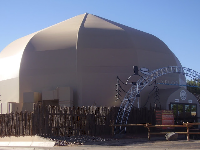
The Explore Navajo Interactive Museum opened in 2007 in the center of Tuba City, next to the historic Tuba City Trading Post.


Tuba City Health Care Corporation (where I worked).

My view on the drive home (heading out of TC).
Saturday, November 17, 2007
Take one step West...or two.
I woke up to a beautiful day so Caillou and I headed out for a day of adventure!
Our first venture was to take State Route 89A towards Sedona, AZ again. We strolled onto Oak Creek Canyon. This is a popular spot for the locals to hold a farmer's market of sorts. After checking out some local artwork, we set our eyes on nature's palette. I will let the picture speak for itself.

Now that you have had a moment to drink it all on, we will continue on the road.

After a long trek through winding back roads, we happened upon the old town of Jerome.

Who wouldn't want to roam these parts? Not much out here...other than the view. Which was enough for me!

Let's not forget the vacationing cattle. They don't mind it here! And they don't seem to mind visitors either.

Route 66 swooped us into the next spot of Seligman. And what did I find in Seligman?

LUNCH! I had never experienced Roadkill Cafe before. So why not now?

A random stop for a Caillou sprint break found me one of the oldest
cacti in the world! (Okay, maybe not the world, but at least on this
trip!)

Oatman Highway was very beautiful. I was able to catch a few random shots before finally laying ground within Oatman.

Looks like a few of the neighbors already got the party started!

A few more stops on my exiting ride. I drove to Laughlin, NV where my sister and Grandfather and I met up with some family back in 1997 during our wild train ride that year. Wow...ten years later. This was my turn-around spot. I then followed the road into the tip of California, but by that time it was too late and too dark to stop for any souvenir photos.
And so, after many more twists, right and left turns, and a few more pit stops, I arrived back at the apartment in Flagstaff...tired, but happy I was able to enjoy my day exploring.
Sunday, November 11, 2007
My 'almost adventure'
I have to admit this is not a good time to be living on a weak budget. There are so many sites to see here, but unfortunately some of them I would love to see...have been sucked into the tourist market and therefore they charge to view them. (Insanity!) So I headed out to find a few spots to view...and didn't get to enter most of them. But, I didn't let that stop me from getting a few pictures of my 'almost adventures'!
This is the...building...outside Meteor Crater.


This is the...building...outside Meteor Crater.

Standin' on the corner in Winslow Arizona, such a fine site to see! It's a girl, my Lord, in a flat-bed Ford slowin' down to take a look at me...

This site was dedicated in September 1999 as a tribute to the 1970 Eagles song (Take It Easy) that made this town 'a town to sing about' on historic Route 66.

Mural covered the entire wall of the building...even the windows aren't real!

This old truck was parked next to the mural.
Next I stopped at a random tourist shop selling various local items...including...petrified wood. (Hmm...I wonder if these are the same people that took the wood from Yellowstone National Park??)

If you don't like any of these selections...there are plenty more to choose from in back!


Hmm...it mentions a possible train crossing, but it mentions nothing about prehistoric potentially dangerous reptiles. Whelp...must be safe!
Next, I traveled Indian Route 12 on my way to...somewhere...


Hey there!
Little did I know...it lead me to Window Rock, AZ. Home of...Window Rock (duh) and the monument to honor the Navajo Code Talkers.

To the right you can see a corner of window rock.
Sorry for the rough photo. As you can tell it was dark out, and my camera is afraid of the dark.
Wednesday, October 10, 2007
Secret local spot.
A spot known by few tourists is Coal Mine Canyon. Beautiful breathtaking views, very hard to locate!


Sunday, September 23, 2007
Dark, smoky Sunset (Crater)
One of my adventures this weekend was visiting Sunset Crater.
.JPG)


.JPG)
Imagine a big...BIG pile of soot.


There is a trail looping the base of Sunset Crater but hiking to the summit is not permitted. A trail providing access to the summit and crater was closed in 1973 because of excessive erosion caused by hikers.
At least it provides a nice view of the San Francisco Peaks!

At the base of Sunset Crater was the Bonita lava flow. It was created in the early 1100's.

What blog would be complete without a few random shots of unique spots of nature??

You would have thought these trees were charred very recently!

The following picture is described as a 'squeeze-up'. The definition is pretty self explanatory when you think about it. A squeeze-up is formed when lava from beneath the surface oozes through a crack in the lava crust.

Squeeze-up
In the valley pictured below lies a series of red cinder-covered vents, marking a fissure along which the most recent volcanic activity occured. Sunset crater began erupting in 1064 a.d. and marks the northwestern end of this fissure.

Cinder Hills overlook
Creeping in on the red rocks
Next, I ventured to Sedona, AZ (picture a tourist trap surrounded by beautiful red rocky mountains) venturing on the historic route 89A.
I wasn't excited over how my pictures turned out, but I was able to capture some of it's beauty.

I wasn't excited over how my pictures turned out, but I was able to capture some of it's beauty.


Subscribe to:
Posts (Atom)